This is Part 2 of my 6 part series of trail guides for Bergslagsleden. Please read my introduction and epilogue to this trail here if you haven't done so yet. This entire trail is also a part of the E1 trail system, and you can read more about that in my E1 trail guides here. Please keep in mind it is still a work in progress. And you can find the official trail website here if you haven't already.
This report covers stages 14-12, or from Laxå to Leken/E18 highway.
The small town of Laxå has a train station where you can connect to Göteborg in the west and Stockholm in the east, and many stops in between. There is the usual helpful things like a pizza shop, supermarket, hostel, etc. in Laxå, but not much else. The Leken area is right next to the E18 highway and has daily bus connections to the town of Karlskoga in the west and the city of Örebro in the east. Örebro is about 28km from Leken (about 25-30min bus ride), is a bigger city (sixth largest in Sweden), and has train connections to many parts of Sweden, and will of course have more to offer for resupplying and luxuries.
Hiking southbound on the E1 you continue on Bergslagsleden and the beginning of Västra Vätterleden, and you can read my report on this section of trail here. Hiking northbound the E1 continues on the Bergslagsleden, and you can check out my guide from Stage 12 (Leken) to Stage 8 (Mogetorp) here.
Now on with the show!
---
On my last trip report I was sick with strep throat, yet still managed to have a good hike. This time my health was fine, but other circumstances worked against me, giving me some added challenges--yet once again, I still managed to have a good hike. Again I think this says a lot about this trail, but there were some minor issues that will address. While not quite as visually stunning as my last section hike, these three stages still offer quite a lot of beauty, and the trail continues to be one of the most well maintained trails I have ever hiked on. Trail shelters and access to fresh tap water are fairly common, for instance, and so are trash cans, places to have a fire, and outhouses.
Due to work and family obligations, I unfortunately didn't have much time to devote to exploring everything that these three stages has to offer, which is quite a lot. There are several other trails that intersect with Bergslagsleden in this area, as well as several interesting sights and landmarks. The more I hike Bergslagsleden, the more it becomes one of my favorite trails, and the more I tell myself that I'd like to go back and hike it again one day--I'd love to do a thru-hike of it as a stand-alone trail.
Anyhow, I will apologize for not having any pictures to document the first half (going northbound) of Stage 14. The only way I could work out this section hike was to arrive by train to Laxå at night. It was pitch black outside when I got there, and my humble point-and-shoot camera is not very good at night photography--not to mention that night hiking requires more focus so one does not get lost. So my first night on the trail I just concentrated my efforts on making my way to the Bäckelid trail shelter as a goal, which is roughly in the middle of Stage 14.
Thus we begin there. Right next to the shelter is a lovely little stream with good water (though I boiled for food and tea). Past the shelter is a nice outhouse, then an odd hobbit-like shack, and soon you cross a large bog. Just in time for October, the month that has one of my favorite holidays, my hike took on a very spooky, eerie quality, which I enjoyed immensely. First I walked alone through the dark for several hours in the middle of a secluded forest, then the next day I find myself walking in the rain through a vast bog--and while in the bog, a fog began to creep into the horizon. This fog would remain and only get thicker as the day went on, and become a bit of a challenge later on on the trail.


A mix of backwoods roads and trails after the nature preserve/bog soon take you to the end of the stage at Svartå Herrgård, and along the way there are opportunities to go off trail to see old mines and quarries. There are several different dirt roads and thin trails in this area, and my interest got sparked after passing a few signs and small side-trail markers. So I followed a blue marked side trail a few kilometers before the end of the stage, and it eventually just ended in the middle of the woods with several ancient looking quarries that are now full of water. It had started to rain more while I did this off-trail exploration, and getting pictures of the quarries was difficult because it was not only dark, but they were surrounded by bushes and trees. I had to break out my compass and map to get back on the main trail after this so I wouldn't have to backtrack, and it was a nice little digression.
The beginning of Stage 13 is a pleasant road hike that passes under a few stone tunnels, one of which goes under an active train line. Just past the second stone tunnel I decided to hike off trail because of the weather and to try and save some time. It continue to rain on and off, at times quite heavy and the fog had set in much thicker. I noticed on the map that the trail would go through a few more bogs (neither are nature preserves), and there was nothing of interest noted on the informational map. I've hiked through unremarkable bogs in the rain and fog before, and it's not exactly my favorite set of conditions, so I decided to loop around them on a road to the east. This road should have intersected with both the main trail and a side trail to a spring close to the area marked Lofallsberget on the map. More on this soon.


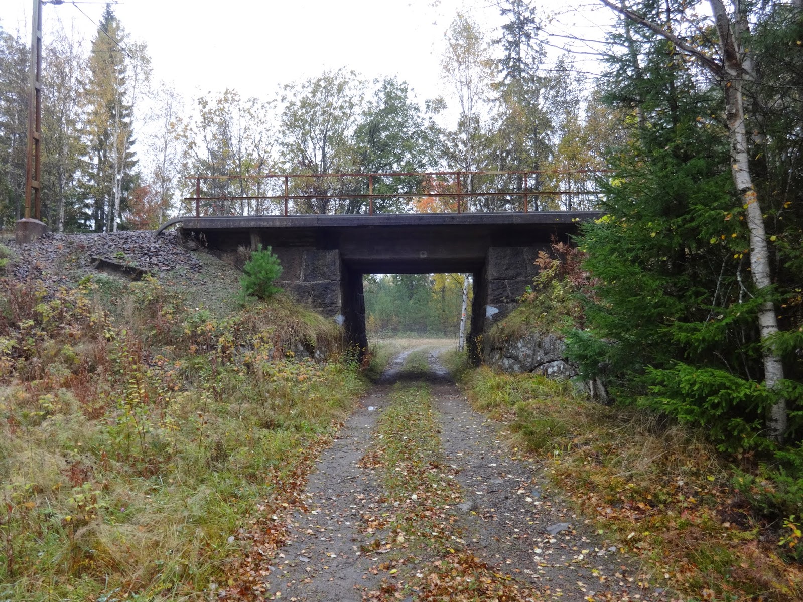 |
| The first tunnel, under train active train tracks. |
 |
| The second tunnel, which goes under what I think were old mining tracks. |

By the time I arrived at the area where the trail should intersect with the gravel road just to the east, the fog was thick enough that I had trouble seeing ahead of me very far, as you will soon see. In this area is what looks like newly cleared forest and several large piles of gravel and stones. I'm not sure if it was due to the fog or the possible removal of trail markers in this new quarry (or both), but I couldn't find the trail. I spent about half an hour hiking around the perimeter of this new quarry, map and compass in hand, and could not find the trail again, so using my best judgement I hiked west on a gravel road that I noticed would eventually loop back around to the trail, close to a lake and a trail shelter.
So if conditions are still like this, just hike west at the clearing down a gravel road, then loop north to east on the road at the next intersections. I ate lunch in the gloomy silence of lake Södra Holmsjön, thankful for the decent trail shelter I sat inside of.


Past this shelter the weather continued to be perfect for horror or vampire movies, and the rain went from sporadic to steady. It also started to get dark, so I followed the trail until it once again got pitch black, which conveniently for me was at a road that would take me directly to the end of the stage, the campgrounds of Sixtorp. At the campgrounds are taps with fresh water, benches, fire rings, and a good trail shelter that is of course free of charge.
I walked behind the shelter when I first arrived to check its condition, and to my surprise there was a badger there sniffing around. I figured it would be afraid of me when I saw it and had my headlamp right on it, and it was no more than about 3 meters from me. Yet the furry, plump, cute little night creature just kept on sniffing around for food like I wasn't even there. I said hello to it, and it looked up at me finally, and did nothing. So I said in a firm voice, "Get outta here." Then to my further surprise it started walking towards me, so I stomped my foot and yelled at it, and it seemed to almost reluctantly turn around and trot--not run--away. I really wish I would have thought to take a picture of it. This was the closest I've been to a badger in the wild.
The wind had picked up a bit, so to prevent the wind and rain from blowing into the shelter, I set up my poncho tarp as a kind of front door to the shelter. The next day the rain finally stopped, and I was able to explore the campgrounds more. The outhouses are on the other side of the road, and there are a few fresh water taps.


Just before I was about to hit the trail again, a few cars pulled in, and two men showed up that help maintain not only the campground, but all of Bergslagsleden and the official website. We spoke for a bit, and this is where I learned that it was only a few weeks up until then that the topographical maps were made available on the official website (see: above). I had bought a map to compliment the informational maps that I had printed out, but in the future I will be using the ones on the official site. I was also told by one of them that they always drink lake/stream/spring water on the trail raw (i.e. without any treatment or boiling) and have never had any problems. They were very friendly, and soon after chatting a bit I continued on to Stage 12.
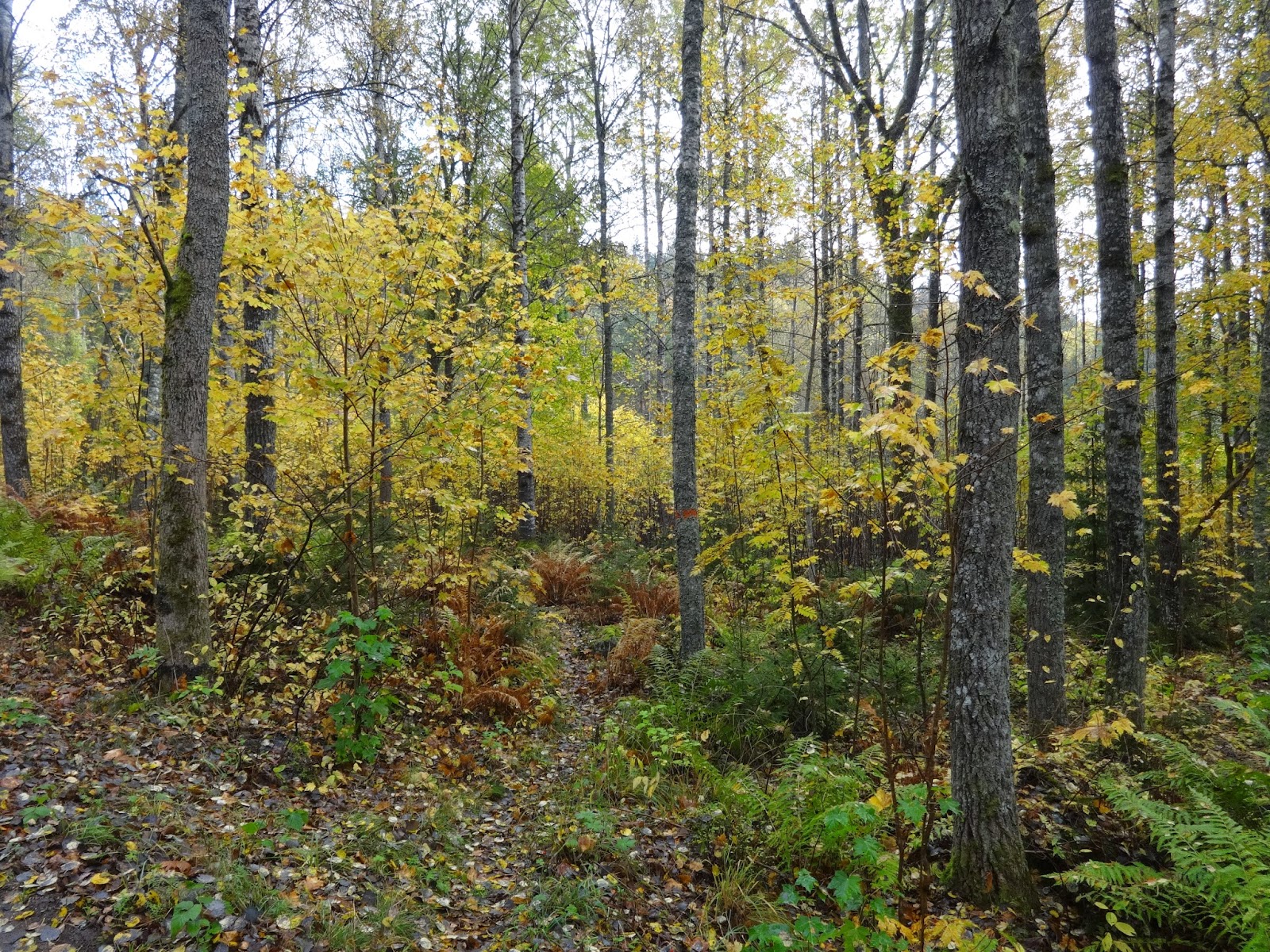
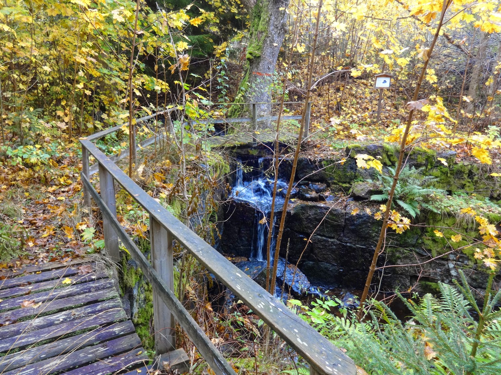
Stage 12 begins in a beautiful little nature preserve, and in general has excellent hiking. I especially fell in love with an old waterfall and stone canal just past the nature preserve. There are also several side trails, one of them--10 sjöars led--is a substantial loop (about 14km each way) that goes all the way over to the town of Karlskoga to the west. I really want to explore this side-trail, and intend on going back to do so in the future, especially considering how nice I found the landscape of Stage 12 to be. You can pick up 10 sjöars led at several spots on Stage 12, but perhaps it's easiest to find it on the dirt road that is just south of the big lake Storsjön.
In the middle of the stage are several great places to spend time for backpackers. Around lake Lillsjön are several trail shelters, a few of which are right by water, and one is right next to a beach. Past the lake area is the Stenbäckens campground, which has taps for water, benches, fire rings, and cabins to rent--but no trail shelter.
I really enjoyed Stage 12, plus the weather got much nicer, so I took a lot more pictures:


 |
| Score! Golden chantarelle! |
 |
| If you look carefully, there is a look-out tower here. |
 |
| The view from the tower. |


The next half of Stage 12 offers more great hiking, but sadly I had to return home at the end of the day. I'll let the pictures do most of the talking. Just before sunset I was able to get to the side-trail that goes east to Hallagården. Close to the end of this side-trail is the E18 highway, where there is a gas station/restaurant, and up the hill past the gas station is the bus stop that can get you to Örebro, which is where I went to catch a train back home.


 |
| Funnel chantarelles. Good, but not quite as good as golden ones if you ask me. |


 |
| Come here horsey! |
 |
| Nice horsey. |


