----------
This post covers Stage 10, Hasteröd-Lysevatten, of the
official guide to the trail.
You can also check out my report on the section before this one (hiking southbound), Stage 11.
If you have not already read the introduction to this trail guide, you can check it out by clicking here. It has a list of reports on other sections I have hiked plus other important/useful background information in general--so please read the introduction first before reading my reports.
----------


The shelter itself is good, and has a good fireplace. It is close to the water, but this is not an ideal swimming lake, at least not there close to the shelter. The shore was muddy and shallow. I ate lunch at the shelter and enjoyed the nice weather before moving on. As I left I noticed that there was also an outhouse and a trash can behind the shelter.
The trail continues in the forest, passes another open clearing (the result of more logging), as well as passes another four lakes along the way. There is also a lot of tall grass and brush to wade through weaving around all the lakes.


Eventually the trail follows a dirt road that intersects with a paved road and the large lake Västersjön. Around the lake the trail goes back into the woods and will go up in elevation to a nice view of the green sea of trees all around.


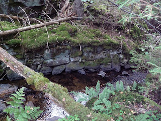
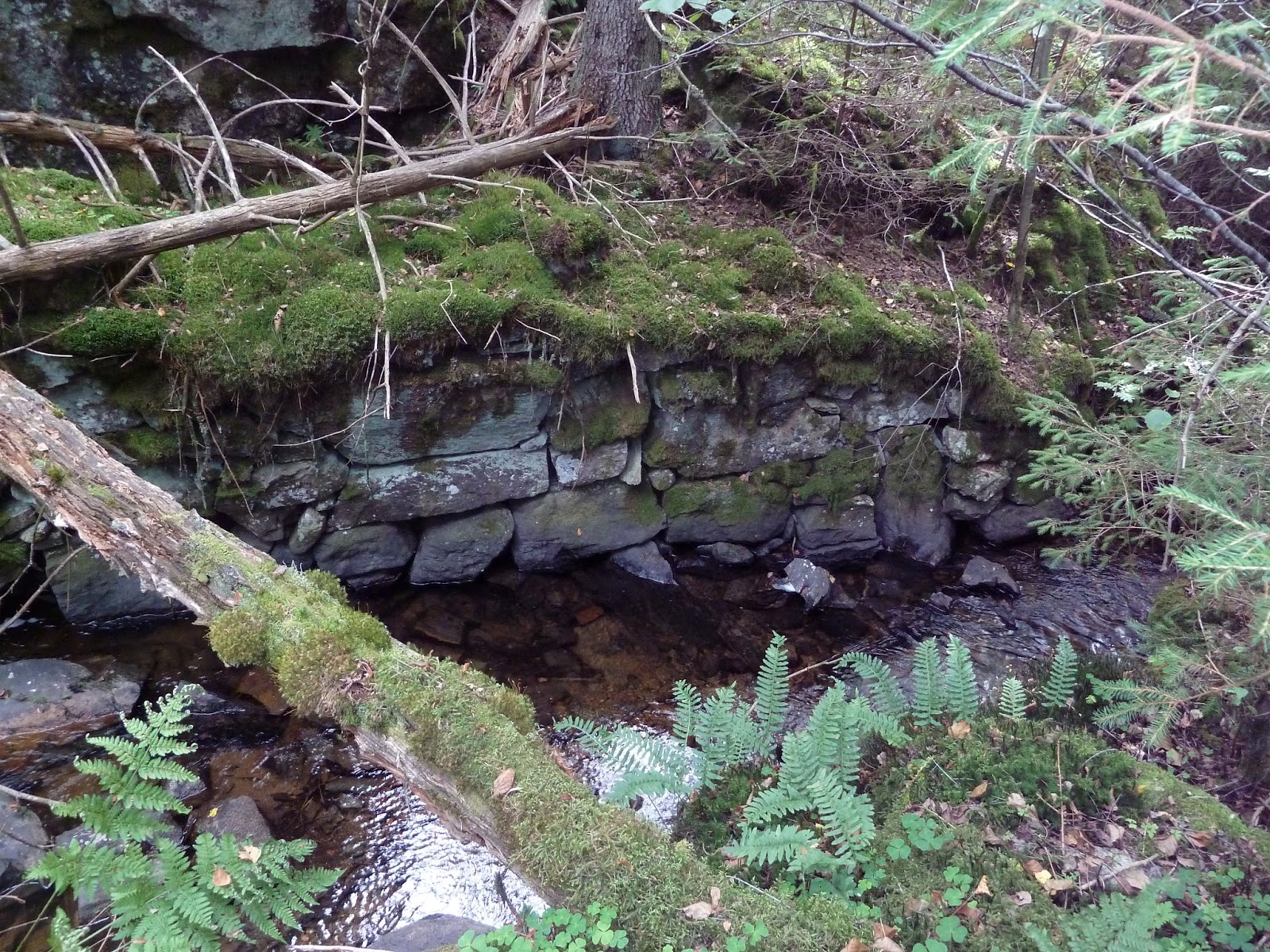
It is this part of the stage that felt the most undisturbed rather than the north part, climbing up and down the thick, green hills. There is one small lake to pass, and then another large lake (Rödvatten). The north end of the lake has a great view of the lake, along with a lovely stone bridge over a stream that feeds out of the lake and that you will follow for a bit. This area is a really cozy trollskög, with cliffs, tall trees, ferns, mushrooms, and moss. I took my time here, and also really liked crossing over the stream a few times and admiring the old stonework that had been put into the waterway.


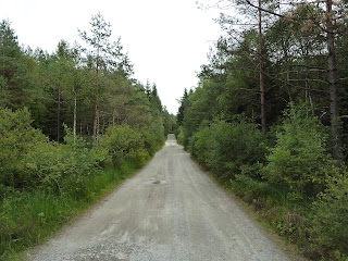
After the trollskög, you will follow a dirt road that goes to the end of the stage, thought I didn't really notice an official endpoint. You will also pass through two large lakes but without having easy access to them. If you are looking to swim or fill your water bottles, I suggest you wait until the beginning of the next stage, where there are two lakes with easy access to good water.

This stage took me about 7 hours to complete, including a long break for lunch and several short breaks to enjoy the nice views, and hiking at a mostly moderate pace. Make sure to be ready for a more intense stage if you are going southbound, as Stage 9 is a challenging and beautiful section that will require more energy and attention.
If you get to the end of this stage later on in the day, I suggest you make camp at the beginning of Stage 9 where there is a nice shelter (that is not mentioned in the official guide and the shelter symbol is partially obscured on the map). If the shelter is full, there are places near the two lakes by the shelter where one can set up their own shelter with little/no problems. Shelters being full and running into more backpackers will be more of an issue as the trail gets closer and closer to Kungälv and Göteborg to the south, which is a starting point for many people hiking northbound--especially in the summer.
Next is one of my favorite parts of the trail, Stage 9.
* This is an easy, straight forward, and pretty section of trail. I am again at odds with the official trial guide, which gives this an orange "average" difficulty rating; but I found this stage to be quite pleasant hiking, plus there is plenty of water sources, and one shelter on the trail and another one very soon after the endpoint (both of good quality and location). This is not to suggest that it is not without challenges, of course, as there are a fair amount of hills to climb up and down and thick plant life to plow through (not to mention lots of bugs if you are here in the summertime), but nothing that was too crazy. And my feet stayed quite dry, though I again had good luck with sunny weather.
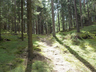
There is also some confusing information given on the official guide, which states that there is a "natural...virgin forest" in the northern portion (around Gunnarsvattnet lake)--yet much of this area (as you will soon see in the pictures below) has clearly had logging done on it. Perhaps this is an editor's prank on the part of the official guide? In spite of a good bit of logging done in the area, there is still plenty of thick woods to hike through, with a lot of both broad-leaf and pine trees.
The stage begins and ends on roads, however, and there are no bus stops at either end. If you follow the 167 highway (which you will cross over) east, after about 6-7km you will get to the town of Lilla Edet, which has a supermarket and public transportation.


In and out of forest trail and dirt road, there will be a longer stretch of woods and then soon after the shelter that overlooks Djupevatten lake.
There is also some confusing information given on the official guide, which states that there is a "natural...virgin forest" in the northern portion (around Gunnarsvattnet lake)--yet much of this area (as you will soon see in the pictures below) has clearly had logging done on it. Perhaps this is an editor's prank on the part of the official guide? In spite of a good bit of logging done in the area, there is still plenty of thick woods to hike through, with a lot of both broad-leaf and pine trees.
The stage begins and ends on roads, however, and there are no bus stops at either end. If you follow the 167 highway (which you will cross over) east, after about 6-7km you will get to the town of Lilla Edet, which has a supermarket and public transportation.


 |
| Virgin forest? |
 |
| You're kidding, right? |
In and out of forest trail and dirt road, there will be a longer stretch of woods and then soon after the shelter that overlooks Djupevatten lake.


The shelter itself is good, and has a good fireplace. It is close to the water, but this is not an ideal swimming lake, at least not there close to the shelter. The shore was muddy and shallow. I ate lunch at the shelter and enjoyed the nice weather before moving on. As I left I noticed that there was also an outhouse and a trash can behind the shelter.
The trail continues in the forest, passes another open clearing (the result of more logging), as well as passes another four lakes along the way. There is also a lot of tall grass and brush to wade through weaving around all the lakes.


Eventually the trail follows a dirt road that intersects with a paved road and the large lake Västersjön. Around the lake the trail goes back into the woods and will go up in elevation to a nice view of the green sea of trees all around.


It is this part of the stage that felt the most undisturbed rather than the north part, climbing up and down the thick, green hills. There is one small lake to pass, and then another large lake (Rödvatten). The north end of the lake has a great view of the lake, along with a lovely stone bridge over a stream that feeds out of the lake and that you will follow for a bit. This area is a really cozy trollskög, with cliffs, tall trees, ferns, mushrooms, and moss. I took my time here, and also really liked crossing over the stream a few times and admiring the old stonework that had been put into the waterway.


After the trollskög, you will follow a dirt road that goes to the end of the stage, thought I didn't really notice an official endpoint. You will also pass through two large lakes but without having easy access to them. If you are looking to swim or fill your water bottles, I suggest you wait until the beginning of the next stage, where there are two lakes with easy access to good water.


This stage took me about 7 hours to complete, including a long break for lunch and several short breaks to enjoy the nice views, and hiking at a mostly moderate pace. Make sure to be ready for a more intense stage if you are going southbound, as Stage 9 is a challenging and beautiful section that will require more energy and attention.
If you get to the end of this stage later on in the day, I suggest you make camp at the beginning of Stage 9 where there is a nice shelter (that is not mentioned in the official guide and the shelter symbol is partially obscured on the map). If the shelter is full, there are places near the two lakes by the shelter where one can set up their own shelter with little/no problems. Shelters being full and running into more backpackers will be more of an issue as the trail gets closer and closer to Kungälv and Göteborg to the south, which is a starting point for many people hiking northbound--especially in the summer.
Next is one of my favorite parts of the trail, Stage 9.